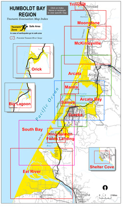
The new maps, developed from counterparts generated by HSU and tsunami inundation areas charted by the California Geological Survey and the California Emergency Management Agency, incorporate the latest information. They will be changed or updated as new scientific data become available. They assume a tsunami triggered by a magnitude 9 earthquake from the Cascadia subduction zone. Subduction, a geologic term, refers to a convergence of tectonic plates when one plate moves under another, sinking into the Earth’s mantle. The Cascadia fault runs from northern Vancouver Island to Northern California.
The new tsunami preparedness maps are intended to support tsunami evacuation planning by individuals and families, not for other purposes. They do not represent how far an actual tsunami might penetrate inland. Instead, they depict safe zones and zones that may be at risk, delineated by easy-to-recognize geographic markers such as streets and roads. Download and study the new maps here (PDF).
A fresh set of tsunami brochures publishing the 14 new maps will soon be available.
In most of Humboldt County, the boundaries depicted by the maps between white safe areas and yellow tsunami zones are marked by Entering and Leaving Tsunami Zone signs. If a great earthquake occurred nearby, the first tsunami surges could arrive in as little as 10 minutes. There might be no time for sirens to sound or other warning messages to be disseminated before the first surges struck.
Earthquake shaking that lasts 20 seconds is considered the warning to drop down to the ground, take cover under a sturdy piece of furniture if one is nearby and hold on to it. People in yellow areas should evacuate immediately on foot or as soon as it is safe to move. Roads might be impassable.
Posted to coincide with Tsunami Preparedness Week, which started Mar. 25, the new tsunami maps include no information about the probability of a tsunami hitting the Humboldt region. Nor do they reflect how a tsunami might actually affect the area.
Online Resources
Detailed information on how to prepare for earthquakes and tsunamis is available in the magazine Living on Shaky Ground: How to Survive Earthquakes and Tsunamis in Northern California. It is online at humboldt.edu/shakyground and available from the Humboldt State University Geology Department at (707) 826-3931.
In addition to HSU, partners in the Redwood Coast Tsunami Work Group include local, state and federal agencies, tribal, relief and service groups and businesses in the tri-county region. Details are posted at humboldt.edu/rctwg.