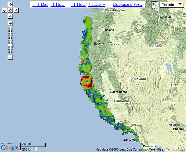
Many more data will have to be collected and analyzed before the eddy’s impact can be fully assessed, but its size is exceptional; it is approximately 170 kilometers (110 miles) in diameter, has speeds up to 70 cm/s (1.5 mph), and a three-dimensional physical structure.
Dr. Greg Crawford, HSU’s Chair of the Department of Oceanography and Interim Associate Dean of Marine Sciences, describes the eddy as the largest, most consistent feature on the California littoral from August through October of this year. “This is exciting in scientific terms because it has received relatively little examination in the past,” Crawford said.
The eddy has been observed previously. In the early 1990’s, Dr. Gary Lagerloef of Earth and Space Research reported evidence of the eddy using satellite and shipboard observations.
As to the eddy’s significance, Crawford explained, “We suspect this could play a big role in determining larval dispersion in a region of the ocean that is relatively highly productive. Fish and crab larvae and small plankton species don’t swim very well, so they get pushed around by the currents. We’re not sure yet about the eddy’s impact on species propagation and feeding patterns, but it could be considerable.”
The eddy has complex circulation structures that can modify water pathways. These effects could, for example, interrupt the flow of nutrients to the south.
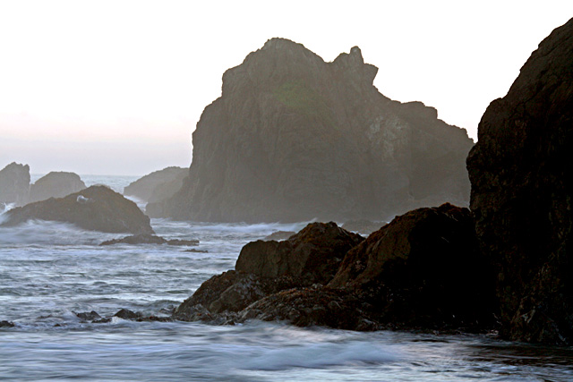
Eddies—immense, swirling masses of ocean water usually seen near continents—have been observed along the coast before, but the Cape Mendocino phenomenon appears to be a resilient feature.
Some eddies are highly productive—bearing voluminous marine life—while others are considered “watery deserts,” more or less devoid of species, Crawford said.
The eddy’s discovery is a major benefit of a long-range radar installed in mid-August at Shelter Cove by Dr. Shannon Stone, Crawford’s lead engineer on the radar project, and Laurie Roy, the project’s research technician (and an HSU Oceanography alumna). The installation bridged an extensive gap in coverage provided by the Coastal Ocean Current Monitoring Project (COCMP), a network of small radars stood up in recent years at key points along the California coast. The COCMP is funded by the state of California through the State Coastal Conservancy.
Humboldt State’s role in the project, which keeps tabs on coastal currents continuously and will provide crucial information to fishermen, ocean resource managers and pollution response teams, is the installation and maintenance of five radar outposts from Crescent City to Shelter Cove.
Named CODAR (Coastal Ocean Dynamics Application Radar), and manufactured by Codar Ocean Sensors, Los Altos, the high-frequency instruments enable scientists to track surface currents in near-real time. “They work a little like police radars,” according to Crawford. “In this instance, we bounce radar signals off very small ocean waves that get moved around by the currents. We can scan in different directions automatically.”
Crawford, Stone and two collaborators on the eddy, Dr. John Largier and Dr. Chris Halle of the Bodega Bay Marine Laboratory at U.C. Davis, will present their findings to the American Geophysical Union conference in San Francisco in December. The COCMP network allows continuous ocean monitoring of roughly 2,000 kilometers (1,200 miles) of the western United States continental shelf, from south of Tijuana, Mexico and north to the Columbia River.
The radar system will also likely be a key part of monitoring the marine protected areas (MPAs) mandated by California’s Marine Life Protection Act of 1999. Similar to land-bound wildlife reserves, the MPAs are designed to protect natural diversity and abundant marine life, maintain the integrity of marine ecosystems and manage them carefully. The marine environment is constantly threatened by coastal over-development, pollution and excess fishing. State-of-the-art monitoring is crucial to limiting human impact.
MPAs already exist in central California. Designs are in place for north-central California and being developed for southern California, after which the effort will turn its focus to the North Coast.
The radar network will provide assessments of the connectivity and effectiveness of MPAs. It also provides unique information—like the Cape Mendocino eddy—to the managers of California’s national marine sanctuaries who monitor the health of some of the state’s coastal ecosystems.
The COCMP program is a key component of both the Central and Northern California Ocean Observing System (CeNCOOS) and the Southern California Ocean Observing System (SCCOOS). For example, when the Cosco Busan spilled 53,500 gallons of oil into San Francisco Bay in November 2007, the authorities relied on surface current patterns from CeNCOOS high-frequency radars to track the spill’s trajectories, particularly outside the Bay.
Likewise, ocean monitoring can be a literal lifesaver when Coast Guard Search & Rescue teams are hunting urgently for the missing. Surface current patterns can help pinpoint the trajectories of people and vessels that have been adrift for hours or days.
The COCMP is also a component of a strategic monitoring array, the Pacific Coast Ocean Observing System. PaCOOS provides vital information about the impact of climate change on the California Current Large Marine Ecosystem. The network is part of a nationwide federal initiative to protect marine life, manage fishery resources and gauge the impact of climate change on an
ongoing basis.