Salt water explodes in a gigantic onrush against the coast, pulverizing the community of Orick and the Redwood Park Information Center as it engulfs everything inland with devastating speed, over expanses no one foresaw.
The Japanese don’t have to imagine this. It happened to them on March 11th. Their vaunted seawalls afforded as much protection as tissue paper.
Such devastation had ripped through Japan before, albeit hundreds of years ago, in 869 A.D. Paleoseismologists were aware of it, but civic planners didn’t build to it.
The Orick scenario is not imaginary, either. Oral history accounts of the Yurok people suggest that water heights of nearly 60 feet deluged that section of the Redwood Coast in the distant past. It is one of a number of places along the Pacific Northwest littoral where tribes have similar communal memories.
Might there be some way to predict Great Tsunamis, however inexactly, which destroy lives by the thousands in near-countless numbers in a gigantic spasm? Could scientists develop a method for establishing the prehistorical recurrence of tsunamis across centuries of time along the California coast?
Readying for future tsunami onslaughts requires a thorough understanding of what has happened long ago. Humboldt State University is taking the lead in the 23-campus California State University system to gather the data necessary to understand the state’s tsunami risks better. HSU faculty scientists and students are pioneering research in an academic discipline scarcely known a generation ago: paleotsunami science.
The basic research consists of dating tsunami deposits—micro-fossils and marine sediments—that faculty and students extract when drilling for cores in diverse coastal areas. The slender cores, sample deposits, are analyzed and dated, and then correlated with similar sediments found elsewhere.
“What ultimately we’re trying to do is come up with a probabilistic tsunami hazard assessment,” says HSU Geology Professor Lori Dengler, a world expert in earthquake and tsunami mitigation and principal investigator for the project. “‘Probabilistic’ means calculating the likelihood of the maximum kind of event we might expect, how probable it might be, and how frequent it might be. Evaluating tsunami deposits on shore tells us how far the water reached in the past. That’s vital in preparedness and evacuation planning.”
Under a $40,000 contract between Humboldt State and the California Geological Survey, findings derived from collected cores will be archived in a unique database. It will enable scientists to track the occurrence—and recurrence—of California tsunamis, reaching back to prehistorical eras for which there are no written records or chronicled observations.
The prehistorical record is of crucial importance for tectonically-active northern California. The largest fault system in the contiguous 48 states dives beneath the Pacific Northwest coast. Running from northern Vancouver Island, British Columbia, to northern California, this fault system or “megathrust” is only about eight miles beneath Eureka and the Humboldt Bay Region.
The fracture is named the Cascadia Subduction Zone. Scientists say the fault generates a monster earthquake in periods stretching from several hundred to about a thousand years, with an average of about every 500 years. As for the next one, there is believed to be a 30 percent chance it could happen within the next 50 years—or during tonight’s ballgame. The potential exists for a rupture to occur at any time.
Megathrust earthquakes cause the sea floor to be pushed up, generating not only strong ground shaking, but also very large tsunamis. They can be large enough to inflict damage on coastal regions many thousands of miles away.
The March 11 tsunami triggered from Japan was only the latest event to cause damage to California. What is more, numerical modeling shows a number of source areas that pose a threat: great earthquakes originating in the Eastern Aleutian Subduction Zone, the tectonic plate boundary that stretches along Alaska’s Aleutian Islands chain. They have the potential to impact coastal communities with run-ups on the order of 20 feet or more in some locations.
The mammoth challenge in preparing for tsunamis originating from the Cascadia and Aleutian zones lies in the nearly non-existent historical records of large tsunamis along the U.S. West Coast. It was this dearth of evidence that led to the California Geological Survey (CGS)’s decision to develop a paleotsunami database, and support work to identify prehistoric tsunami deposits along the California coast from Crescent City to the Mexico border.
Humboldt State University is in the forefront because it has been pulling together the basic research, field work and knowledge for nearly two decades. Its Department of Geology boasts a corps of tsunami experts. “There aren’t many institutions—none of our size—that have the level of expertise and capabilities we have,” Dengler comments.
Dengler and Rick Wilson, CGS engineering geologist, say the Japan disaster is strong evidence that scientists should think anew about Cascadia. It heightened the importance of gathering paleotsunami data for the entire California coast. Information about the March event is still preliminary, but, in Wilson’s words, Japan’s cataclysm raises the question: “Should we expect larger slips offshore of California than have been predicted in the past?”
Wilson was referring to the fact that the scope and scale of the large vertical slip that triggered the March upheaval were a surprise to Japanese scientists, who had underestimated the slip’s potential extent.
“That’s one of the main reasons for this paleotsunami project,” explains Dengler. “Underestimation leads to huge losses of life. Paleotsunami data take you back at least a few thousand years further, and they are even more vital here than in Japan because our historical record for Cascadia is so short. It’s like trying to describe an entire elephant by touching the end of its trunk.”
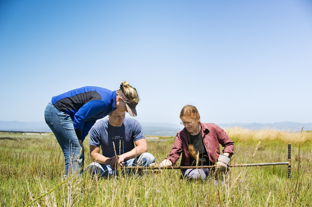
This past summer, HSU micropaleontologist Eileen Hemphill-Haley and geology graduate student Nick Graehl collected core samples in such locales as Half Moon Bay, Point Reyes, and Bodega Bay. This was phase one of the field program to gather geological evidence for past tsunami inundations on the coast, in an area that would have been strongly impacted by trans-Pacific tsunamis emanating from the Aleutian Subduction Zone. Paleotsunami deposits had not been documented previously in that area.
The Humboldt State team worked jointly with scientists from the U.S. Geological Survey as well as the California Geological Survey. They will proceed with coring numerous additional localities along the central and southern California coast in coming months. Initial field results are scheduled to be presented at the annual meeting of the American Geophysical Union in San Francisco in December.
As for the redwoods region, grad student Graehl says, “Here on the northern California coast, we live at a triple junction where three tectonic plates are colliding with one another. Our tectonic setting makes this area an epic place to study geology. It was living here that got me interested in earthquakes and tsunamis. For me this is a dream job: I know the work I’m doing will ultimately save lives and property and I feel good knowing that. It feels good to get down and dirty coring for earthquakes and tsunamis, too! Also, I’ve been able to work in some remote and beautiful locations that people rarely get to see."
Wilson underscores that tsunami deposits will help scientists plot out how often Great Tsunamis have occurred along the California littoral. “We need to consider how often really large events occur along Cascadia,” he says. “Understanding recurrence times has major implications for emergency scenarios and evacuation planning.”
Although the new paleotsunami database is expected to be an invaluable tool, earthquake and tsunami prediction is likely to remain a devilish task despite the gains in understanding achieved in recent decades about Cascadia.
“When I first came to Humboldt State in 1979,” recalls Dengler, “the debate centered on ‘Does this Cascadia Subduction Zone even have earthquakes?’ Some people said, ‘Oh, no, it’s such a young and warm tectonic plate, it’s just sliding, not slipping. There’s no friction at all.’ Well, we were able to rule that out really quickly. That’s progress. ”
Yet, a new book by veteran Canadian journalist Jerry Thompson, “Cascadia’s Fault: the Coming Earthquake and Tsunami that could Devastate North America,” analyzes the obstacles to prediction, suggesting that earthquakes, like car wrecks, are rooted in too many variables to predict reliably. For example, speeding is known to be a factor in car accidents, but only a fraction of speeding violations results in crashes.
Even as a conjunction of factors starts to form, setting the stage for an accident, its extent and severity hinge on a host of other, contingent factors —weather, road, light and traffic conditions, driver reaction times, the number of cars involved, and vehicle safety features, to name but a few.
In the book, Dengler tells Thompson she started her career as a prediction optimist, but today she is only absolutely certain that “the next Cascadia earthquake is one day closer today than it was yesterday.”
On the other hand, Dengler has led detailed, post-tsunami reconnaissance missions to such places as Indonesia and Chile. She is convinced that, however imprecise predicting the probability of earthquakes and tsunamis remains, community awareness can enable everyone to survive if residents are taught to heed the natural warning signs.
Historical awareness saved all of the residents of Langi village on Simeulue Island off the west coast of Sumatra at Christmas 2004, when the tsunami produced by a magnitude 9.3 earthquake wiped out the entire village, leaving no structures standing. Yet no one died in Langi because of the island’s lengthy oral tradition about great waves following earthquakes. Even though Langi residents had only eight minutes to flee the surges, every man, woman, and child escaped. Even the elderly and disabled survived as family members and neighbors put them into garden carts to push them up a hill.
In Phuket, Thailand, Dengler discovered during a post-event reconnaissance that an alert schoolgirl who had learned about tsunamis two weeks before in the classroom warned her parents when she noticed frothing bubbles on the sea’s surface as the tide receded suddenly. Everyone cleared the beach and holed up in the upper floors of a hotel. Everyone survived.